
An INHERIT study shows how augmented reality, combined with building information modelling and real-time sensor data, can help conservation professionals inspect defects and plan renovations on historic buildings.
Most augmented reality (AR) applications developed for cultural heritage to date have focused on visitor engagement, storytelling and tourism, offering an appealing but largely passive experience. INHERIT proposed a new framework that positions AR as a working tool that helps heritage professionals to inspect structural conditions, compare renovation options and receive maintenance recommendations directly inside an AR environment.
The framework was validated on a residential heritage building constructed in 1928 in Gdynia, Poland and presented in the study “Augmented reality in the digital preservation of cultural Heritage: case study in Poland” authored, among others, by INHERIT partners from University College London (UCL) and the Polish heritage-restoration company Fasada.
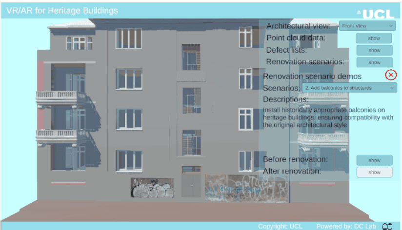
The system brings together images, laser-scanned point clouds and a Heritage Building Information Model (HBIM) built in Revit, integrating them in the Unity engine. The resulting digital twin is then deployed through Microsoft HoloLens 2 headsets, using Microsoft’s Mixed Reality Toolkit, so that users can navigate the building’s model, overlay point cloud data, and interact with it through simple hand gestures.
In practice, this means a conservation professional wearing the headset can look at a cracked wall on site and immediately see its type, severity and recommended repair, drawing on real-time sensor data installed in the building. The same platform lets stakeholders compare predefined renovation scenarios – such as crack repair, the addition of balconies, or the removal of graffiti – viewing “before and after” states side by side to support informed, shared decisions.
The framework was assessed through a stakeholder forum and survey involving 25 participants, 19 of whom responded to detailed questions on usability and functionality. Feedback pointed to clear priorities for future AR tools in this field: participants unanimously valued the integration of real-time sensor data and real photographs, while agreeing that highly detailed, decorative 3D models were not necessary for the tool to be useful. Respondents also highlighted the value of brief onboarding or training before using the AR interface.
The authors note several limitations that will guide further development, including the framework’s reliance on specialist hardware, its dependence on high-quality input data and the current focus on spatial and sensor data rather than qualitative information such as historical context or conservation guidelines – an area flagged for future work through linked databases or interactive annotations.
Read the full publication here
—
Cover photo by UCL